
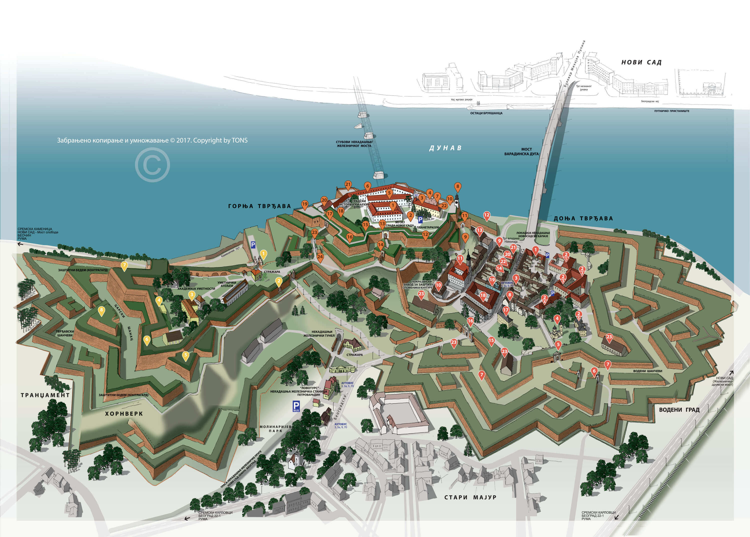
Petrovaradin Fortress
Petrovaradin Fortress, as Gibraltar on the Danube, dominates over the unpredictable space of the civilisation crossroads of the European history with its monumental architecture, complex fortification and military-strategic position.
The explorations into the foundations of the Petrovaradin Fortress revealed settlements dating back to the Palaeolithic Age and particularly significant Eneolithic Age (around 3,000 years B.C.) period that the first earth fortification with wooden palisades dates back to. After that, having recognised the superior position of the fortress, the Celts and Romans built fortifications at the same site. The rise of the Hungarian state in this region during the Middle Ages, provided for the control over the Petrovaradin rock up to the arrival of the Turks who conquered it in 1526 as part of their campaign to Vienna. The Ottomans ruled fortress on the Petrovaradin rock for more than 160 years, all until the Great Vienna War, namely until 1691 when the Austrian Empire definitely took over the control of the fortress after persistent struggle.
The constant threat from a counterattack of the Turkish army conditioned an efficient reaction of the Royal War Council in Vienna in the form of a more permanent solution for the defence of the new border area.
The need was imposed to construct a completely new fortification capable of breaking any potential penetration of the Turkish armada with its fortification installations. The foundation stone of the modern fortification complex was set in 1692.
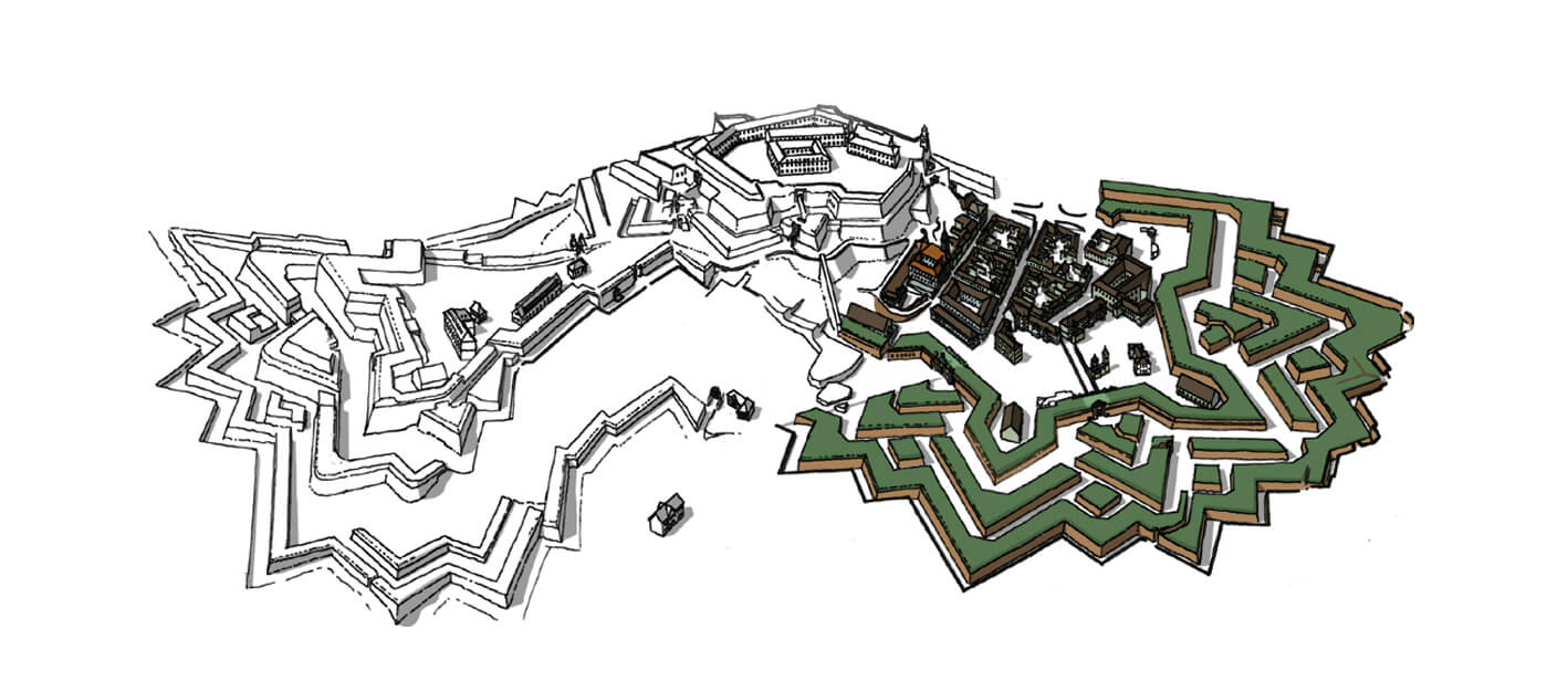
The impressive fortification was systematically constructed at three mutually connected levels: the Upper Fortress on top of the Petrovaradin rock, the Lower Fortress – Wasserstadt (Water Town) with Suburbium, and a protruding fortification structure – a two-horned Hornwerk bastion on the southern side. The most attractive piece of architecture is embodied in the Underground military galleries, a complicated defence-communication and mine system of corridors spreading in the length of more than 16 kilometres.
The long-lasting works on the Petrovaradin Fortress, characterised by numerous temporary interruptions and a great number of human casualties, ended in 1780. Being originally constructed as the first class defensive fortification, with a large garrison numbering several thousands of soldiers and numerous artillery, the fortress was later on transformed into a military-administrative centre with a general command and numerous administrative apparatus.
Petrovaradin Fortress was demilitarised by the middle of the 20th century and proclaimed a cultural monument as an exceptional urban-architectural and cultural-historical value.
1 OLD WAR COMMAND POST (HEADQUARTERS): A multi-storey structure located at a former Parade Square used to be the headquarters of the first, namely the old war command of the military garrison. The building was constructed under the orders of Baron Heinrich Nechem, a former general and commander of the Fortress (1694-1711).
2 MILITARY HOSPITAL: The contemporary complex of the Military Hospital encompasses areas and structures of the Lower Fortress bordered by the bastions of the St. Theresa and St. Joseph. The hospital is made up of several structures constructed in different time periods, dating back to the end of the 17th century up to 1920s. The core of the complex are Baroque style buildings of the former Franciscan convent. The complex grew in size by annexing the Church of the St. Francis and the Building of the Fortress Commander. In addition, a modern complex of the Military Hospital also includes the Large Barracks, Isolated Pavilion, and Gunpowder Storage Theresa, a series of casemates between the New and the Assault Gate, as well as the building of the Old War Command at Vladika Nikolaj’s Square.
2.1 BUILDING OF THE FORTRESS COMMANDER: A multi-storey structure recognised for its unique Baroque style decoration constructed at the beginning of the 17th century as a residence of the Fortress commander, General Heinreich Nechem. The front of the structure is decorated with the commander’s family coat of arms standing next to the coat of arms of Srem.
2.2 NEW WAR COMMAND POST, FORMER CHURCH OF ST. FRANCIS: The former Baroque style convent church was constructed at the beginning of the 18th century only having to change its role into a Grain Storage by the end of the century. The great reconstruction of 1807-1809 found a new role for the structure transforming it into a High Command Post for Slavonija and Srem. The gravestone of the Fortress first builder, engineering Colonel Michael Warmberg (- 1703) is preserved until today on the wall of the former church.
2.3 MILITARY HOSPITAL, FORMER FRANCISCAN CONVENT: The construction works were carried out in the period from 1699 to 1772. The convent architecture spawned out of the right-angled foundations with the inner atrium yard and the arcade porch. The convent was converted into a military hospital in 1786 following the orders of Tsar Joseph II.
2.4 GREAT BARRACKS: A multi-storey structure erected in the first half of the 18th century under the name of New Barracks.
2.5 ISOLATED PAVILION: A multi-storey Historicism style structure constructed in 1887. The pavilion is located in the immediate vicinity of the New Gate. Nowadays, the pavilion accommodates the administrative headquarters of the Military Hospital.
3 PHARMACY: The first pharmacy in Petrovaradin was opened in 1765, in the former Main Street that is nowadays called Beogradska Street. The pharmacy was primarily opened for military purposes. Since 1802, the manager of the pharmacy was the pharmacist Franz Schams, born in the Czech Republic. The manager showed the interest in history of Petrovaradin and Fruška Gora area. The pharmacy came into the hands of several proprietors following the departure of the original manager in 1817. One of the proprietors was Teodor Deodat who collected old books and other pieces of art. The pharmacy was a beacon point for poets and artists. The old name of the pharmacy was “At the Golden Eagle’s”.
4 SERBIAN ORTHODOX CHURCH OF ST. PAUL: The electrical power station was converted to serve the purposes of hosting the religious services for military personnel of Orthodox religion in 1922, followed up by the reconstruction works that took place in 1926. The current Serbian-Byzantine outlook of the church can be attributed to the architect Ilija Protić under whose design the church underwent a large-scale reconstruction works in 1992/93.
5 NEW GATE: The New Gate was constructed at the beginning of the second half of 18th century as the Main Gate of the Water Town. The Gate was constructed in the axis of the rampart between the bastions of St. Francis and Maria Theresa. The New Gate is considered one of the largest and most impressive Baroque-Classicist style Petrovaradin gates. The outer facade facing towards the Water Town possesses an impressive central part in the form of the stone portico with a triangular tympanon housing the coat of arms of the Habsburg monarchy. The Gate contains preserved authentic guard quarters, with two cannon openings, as well as parts of the mechanism used to raise and lower a mobile segment of the wooden bridge.
6 WATER TRENCHES GATE: It is located in a triangular rampart ravelin in front of the New Gate. The gate possesses a sub-gate and an elongated stepped wall with guard posts on both sides, used to control the passageway and provide protection from the Danube side.
7 WATER TRENCHES: They were constructed during the second half of the 18th century during the large-scale reconstruction of the Lower Fortress. The trenches represent a single threefold belt of water, earth and dry trenches making up an integral part of an extremely complex envelope of the Lower Fortress. The envelope is made up of a series of fortification structures of the outer defensive line such as ravelins, counter-guards, semi counter-guards and lunettes.
8 “FORTRESS”BARRACKS, FORMERLY KNOWN AS A PAVILION OF THE ENGINEERING OFFICERS: The barracks represent a massive two-storey building of uniquely designed facade. The building was constructed on corner of Beogradska and Nazorova Street. The authentic purpose of the building remained preserved since the date of foundation serving as a part of the military complex in the Lower Fortress.
9 FORMER OFFICER’S TAVERN “KOD SEDAM IZBORNIH KNEŽEVA” (“AT THE SEVEN ELECTED DUKES”): A renowned military, i.e. officers’ tavern in the Suburbium. The tavern was a popular gathering point for at least one and a half century. A multi-storey building was located at the corner of a former Vladike Nikolaja Square and Štrosmajerova Street. The tavern ceased working following the end of the World War I.
10 FORMER BARRACKS USED TO ACCOMMODATE FORTIFICATION CONSTRUCTION WORKERS: The ground floor barracks dating back to the beginning of the second half of the 18th century located on the Ramp pathway, next to the St. George’s Convent. The barracks were used for housing of labour force that was engaged on fortification works. The Infectious Diseases Department of the Military Hospital found temporarily its place within the walls of the barracks. The barracks space is nowadays occupied by the Provincial Institute for the Protection of Cultural Monuments in Novi Sad.
11 ST. GEORGE’S CONVENT AND PARISH CHURCH (FORMER JESUIT CONVENT AND CHURCH OF ST. GEORGE): The building complex represents a monumental structure made up of the church and residences. The church dedicated to the St. George was built in a baroque style (1701-1714.).The eastern side of the church was reserved for massive right-angled basis monastery wings with atrium yard. The construction works on the wings were completed in 1734. The monastery was converted into residences with parish church following the abolition of the Jesuit order that took place at the end of the 18th century.
12 ST. CHARLES’S BASTION OR FOOD SUPPLIES BASTION: The southwestern bastion of the Lower Fortress, on the Danube coast carries the name after St. Karl. The one side of the bastion leaned on the demolished Novi Sad gate, while the other side was facing the Danube moat. The Danube moat side of the bastion ended with a Provisional gate docking area for boats-yawls used to unload goods necessary for normal functioning of the fort. The bastion was constructed at the beginning of the second half of the 18th century as a hollow bastion with series of casemates for protection of vital functions and structures of the fort.
13 BAKERY BUILDING OR LOWER FOOD SUPPLIES WAREHOUSE: an impressive one-storey building, serving as an integral part of the significant construction framework used to supply the Fort. The building complex was made up of a main provisional building with the bakery, food supplies warehouse and a depot for horses and carriages .The Baroque style warehouse was constructed during the first half of the 18th century. The main building made up of massive wall and arches accommodates six preserved bread ovens with decorative chimney caps, as well as characteristic interior stucco decoration.
14 FORMER BISHOP’S RESIDENCE: The Srem diocese was restored following the ouster of Turks from Petrovaradin in 1691. The seat of the diocese was moved to the Petrovaradin Fortress in 1741. The Bishop’s residence was placed in a spacious one storey building on corner of Beogradska Street and Lisinskog Street. The corner of the building, above the cornice holds a stone oval shaped coat of arms of the Srem Bishop Ladislav Sereny (1733-1752).
15 CENTRAL PRISON OF THE SLAVONIAN-SREM HIGH COMMAND IN CASEMATES: The prison dates back to 1769, with encampment areas spreading between the casemates of St. Karl and St. Francis, immediately next to the Belgrade Gate.
16 BELGRADE GATE: The gate represents one of the two (formerly three) main gates of the Lower Fortress. The Belgrade gate is positioned within a curtain wall of the southeastern bastion front between the bastions of St. Benedict and St. Francis on a main road towards Sremski Karlovci and Belgrade. The baroque-classicist style gate was constructed at the beginning of the second half of the 18th century. The gate was used to protect the access point to Suburbium from southern side and represented a most formidable structure of the Water City’s defensive system.
17 THE OFFICER’S PAVILION: The two-storey historicism style freestanding structure was erected in second half of the 19th century. The pavilion was built on an undeveloped stretch of land in the immediate vicinity of the Belgrade Gate. The building was used for housing of officer’s families.
18 LOWER FORTRESS ARSENAL: The monumental structure of the Arsenal used for storing of weapons and military equipment was constructed in second half of the 18th century. The area formerly occupied by old ramparts of the Lower Fortress was designated as a construction site for the Arsenal. The Arsenal building was built in spirit of baroque with simplified designed best suited for the specific purpose of the structure
19 BAN ЈOSIP JELAČIĆ’S BIRTH HOUSE : The birth house of the Croatian ban and the Austrian count Josip Jelačić (1801-1859) was built in 1745. The house represents the most beautiful private property in Petrovaradin. The birth house represents a unique example of baroque architecture not only reserved for the compounds of the Fortress’s Suburbium but also on a broader scale of Vojvodina. The architecture is characterised by a high mansard with a triangular tympanon and angled vollutes finish.
20 BUILDING OF THE RIVER NAVAL FORCES BATTALION (THE SO-CALLED “ŠAJKAŠI”): The Empress Maria Theresa formed a Šajkaš battalion in 1763 due to the constant Turkish threat. The battalion was mainly made up of Serbs-border men. The headquarters of the battalion were in the Lower Fortress, in the Glavna Street. The headquarters’ building was a storey structure of unique decoration. The coat of arms of the Šajkaš battalion was placed above the arched orbed entrance with symmetrically positioned lion figures. The coat of arms is nowadays kept in the Museum of Vojvodina. The wooden polychromatic sculpture of the Virgin of the Immaculate Conception with Christ.
21 MAIN “MALTARIN” TOLL POINT: A large angled one-storey building of decorative facade, where “maltarin” used to be collected according to the historical sources. The word “maltarin” stands for the toll that was collected for crossing over the pontoon bridge. The Baroque style building was constructed during the second half of the 18th century. The stone figure of the St. Antonius Padua with Christ is placed within the expressed niche the facade in the Glavna Street.
22 MAGISTRATE: The building is located on a corner of the Beogradska and Lisinkog Street as one of the oldest structures in the street constructed during the first half of the 18th century. The ground floor and the first floor were reserved for the offices of the Mayor. The building was home to the Archives of Vojvodina during the period from 1934 to 1942.
23 GUNPOWDER STORAGE: The three typical gunpowder storages were located within the Lower Fortress. The storages were placed in the throats of the St. Benedict’s Bastion, St. Francis’s Bastion and St. Theresa’s Bastion. The construction works on the storages began during the second half of the 18th century. The authentic look of the storages was preserved until today. The gunpowder storage buildings are characterised by rectangular basis of massive counterfort reinforced walls and a high protective wall-rampart. The fourth gunpowder storage named Joseph within the St. Benedict’s ravelin in front of the Beograd Gate. The fourth structure is made up of a central triangular basis part housing the gunpowder storage reinforced by protective wall and two casemated wings with cannon openings facing the trench.

1.) ARSENAL (CANNON AND AMMUNITION STORAGE OR MAMULA’S BARRACKS) is a multi-storey, rectangular baroque style structure with the inner atrium that was constructed at the beginning of the second half of the 18th century. The building occupies a central position at the Upper Fortress and dominates over the landscape with its massive structure. The Arsenal was used to accommodate and transport of heavy pieces of artillery weapons, arms and equipment. Nowadays the Arsenal accommodates the City Museum of Novi Sad.
2.) PARADE SQUARE: An open square area located in front of the Arsenal, paved with cobblestone that was used for lining up of the military troops as well as for other parade, garrison and state festivities due to a clear view it provided and its central position.
3.) OFFICERS’ PAVILION: One of the oldest structures preserved until today within the area of the Upper Fortress. The Pavilion was constructed under the name of Double or Löffelholz’s Barracks at the beginning of the 18th century in the Baroque style. It was reconstructed at the beginning of the 1960s according to the design of an architect Dragiša Brašovan. The reconstruction implied the extension of the Pavilion to include the restaurant with a large terrace as well as the representative salon area of the city protocol located on the upper floor.
4.) TERRACE: The area in front of the Officers’ Pavilion is an exclusive terrace that provides a unique view over the Danube River and the city of Novi Sad.
5.) SIMPLE BARRACKS: The building was erected during the first decades of the 18th century in the Baroque style. The current outlook of the structure is the result of the reconstruction that was carried out during the middle of the 20th century. The reconstruction included removal of a southeastern part of the structure that was damaged during the bombardment of the allied forces in 1944. The foundations of the medieval defence citadel were revealed underneath the damaged part of the barracks. The southeastern side of the barracks at the basement level was adapted in a series of premises that were to be occupied by old artisans and restaurant owners.
6.) LONG BARRACKS: The recognisable silhouette of the Petrovaradin Fortress owns its shape to the extremely elongated barracks body. The barracks were constructed at the beginning of the second half of the 18th century to accommodate the military and accompanying administrative task force. The workshops and storages were located at the basement level facing the Danube. The basement level accommodates art studios nowadays, while the upper area is reserved for the hotel “Leopold”, Atelier 61 specialised in tapestry manufacture and Meteorological station.
7.) UPPER FORTRESS FOOD SUPPLIES WAREHOUSE AND BAKERY: It was constructed during the first half of the 18th century, as the main military Upper Fortress food supplies warehouse with three built-in bread ovens. The area currently accommodates art studios and a nightclub.
8.) CLOCK TOWER: It was erected on the northern rampart of the Upper Ludwig’s Bastion during the middle 18th century at the site of previously demolished old tower. The original clock mechanism dating back to the 18th century is functioning until today. The round clock faces, with over three meters in diameter, positioned at all four sides of the tower are unique because of the fact that the large clock hands show hours, while the small ones show minutes so that the people living in Petrovaradin as well as those on ships along the Danube could easily see the time of the day.
9.) STAIRCASE TO THE UPPER FORTRESS: The long and curvy stone staircase has 214 stairs and connects the Lower with the Upper Fortress. The original outlook of the stairways was with straight-line design staircase that was made out of wood and with an entrance gate by the Church of Saint George and it was reconstructed during the middle of the 20th century.
10.) UPPER LUDWIG’S BASTION: It was erected at the protruding northern point of the Petrovaradin rock. The Bastion was named after the military commander Ludwig von Baden (1655–1707) that expelled the Turks from Petrovaradin in 1691. The Upper Bastion is most frequently visited structure at the Fortress, as a remarkable viewpoint dominated by the Clock Tower.
11.) LOWER LUDWIG’S BASTION AND LUDWIG’S GATE: The Ludwig’s Gate was erected on the staircase, at the entrance into the tunnel that leads through Upper and Lower Ludwig’s bastions. The Gate was constructed during the middle 18th century in a Baroque-Classicism style. The Gate was built as a combination of brick and rock squares. The central opening with an arch was sided with pilaster and triangular tympanon.
12.) SAINT JOSEPH’S BASTION: It was named after the Tsar Joseph I of Habsburg (1705-1711). The reign of the tsar marked an era of increased volume of construction works on the Fortress. The main communication directions and access points to the Lower and Upper Fortress were controlled from the high ramparts of the Bastion. Apart from underground counter-mine system of military galleries with loopholes there is also the casemate in the Bastion interior with cannon openings used to defend the Leopold’s Gate. The Bastion currently accommodates the Planetarium.
13.) LEOPOLD’S GATE: The north-eastern Gate of the Upper Fortress was constructed in the second half of the 18th century, in the axis of the rampart that connects the Saint Joseph’s and Innocent’s Bastions, on the route of the so-called Ramp pathway that connects the Lower with the Upper Fortress. The Gate was named after Tsar Leopold I of Habsburg (1657–1705). The oval stone relief with the coat of arms of the Austrian Empire found its place within the gate walls. The motto of the Habsburg monarchy reading VIRIBUS UNITIS (With joined forces) is placed above the coat of arms. The motto is complemented with the engraved year of 1694 as a remembrance to the failed Ottoman siege of Varadin.
14.) GATE OF THE TSAR CHARLES VI: The Gate of Tsar Charles VI or the outer northeastern gate of the Upper Fortress was constructed in the ravelin in front of the Leopold’s Gate. The long bridge was used to connect the Gate with the counter-escarp and the Ramp pathway. The gates, as well as the bridge were constructed in the late 18th century. The Gate was named after the Tsar Charles VI (1711-1740), father of Maria Theresa. The front of the Gate carries the engraving of 1760 commemorating the cessation of construction works on the Fortress.
15.) CONTINGENCY WAR WELL: The well was constructed during the second decade of the 18th century, as an integral part of a unique water supply system of the Petrovaradin Fortress. It is located at a central position within the encaved circular room. The structure of the well is characterised by the massive pillars that carry the dome arch with circular ventilation opening on the top. The diameter of the well is almost 3.5 meters wide while the depth of the well is over 60 meters. The lower parts of the well were constructed with stone ashlars, while the upper part is made out of bricks. The water was drawn from the well by spindle and further on distributed along the underground corridors of the water pathway. Nowadays, the underground gallery of the “Water pathway” is used to connect the well with the City Museum of Novi Sad in the Arsenal.
16.) SAINT INNOCENT’S BASTION: It was named after the Saint Innocent, namely the Pope Innocent XI (1676-1689). The Innocent’s Bastion together with Saint Leopold’s Bastion makes up the oldest bastion that was constructed at the end of the 17th century. The interior of the Bastion is occupied by two casemates with flank-faced cannon openings used to defend the Leopold’s and Court Gate.
17.) COURT GATE: The older of two main gates to the Upper Fortress is positioned in the axis of the south-eastern bastion, between Saint Innocent’s and Saint Leopold’s Bastion, in front of the entrance into the tunnel via cortina and cavalier. The Gate was constructed at the site of the main medieval citadel that was partially incorporated into the Gate structure. The Gate dimensions are impressive – it is 5 meters wide, 8 meters high and the arched tunnel is 50 meters long.
18.) CAVALIER: The highest defensive rampart of the Fortress. The cavalier was constructed at the beginning of the 18th century under the order of Prince Eugene de Savoy who used it as a commanding point during the battle against the Ottoman Empire that took place in 1716 near Petrovaradin. The cavalier was the last defence line and the commanding point of the Fortress commander in times of need.
19.) SAINT LEOPOLD’S BASTION: It is the first fortification structure erected on Petrovaradin Fortress. The foundation stone of the Bastion was laid down by the emissary of the Tsar Leopold I (1657-1705), on October 18th, 1692. The Bastion’s prominent position provided a full control over the Danube flow and its left bank, as well as over the southern and eastern access points to the Upper Fortress. The casemate was constructed within the interior of the Bastion and equipped with cannon openings that were used to defend the Court Gate. Nowadays, it accommodates the gallery of tapestries made by Boško Petrović.
20.) LEOPOLD’S GUNPOWDER STORAGE: It represents one of the oldest structures at the Fortress that was constructed during the first decade of the 18th century. The Gunpowder Storage is entrenched in the hinterland of St. Leopold’s Bastion from the northern side and is protected by the support wall. The massive walls are reinforced by six pairs of brick pillars-counterforts and semi-shaped arch covered by double-deck roof.
21.) MARIA THERESA’S BASTION: It was named after the Empress Maria Theresa (1740-1780) under the reign of whom the construction works on the Fortress entered the final phase. It is the longest Bastion shaped in a form of two semi-bastions. The water tank of the Fortress’s oldest waterworks is located in the depth of the northern semi-bastion. The water tank dates back to 18th century. The most beautiful promenade of the Fortress was formed along the Bastion, at the site of the former earth battlements. The area below the Bastion is occupied by the entrance into the railway tunnel that was dug under the Upper Fortress in 1883.
22.) COUNTER-MINE SYSTEM OF THE UPPER FORTRESS (UNDERGROUND MILITARY TUNNELS): The system was constructed on the stretch of land between the Upper Ludwig’s Bastions up to the counter-guard of the Leopold’s Bastion. The counter-mine system consists of a series of underground military galleries/tunnels with areas used for accommodation of military units and equipment. The fighting lines, combined escarp and counter-escarp galleries with a series of gun holes facing the trench and access road are interconnected by communication galleries, as well as vertical thoroughfares – “elevators” located within the gallery niche walls. The battle lines were permeated by minefields sunken under the trench surface. The counter-mine system of the Upper Fortress is one of the biggest tourist attractions of the Petrovaradin Fortress.
23.) MOLINARI’S GATE: The Gate is located on the main driveway to the Upper Fortress. The Gate itself is made up of two gates: inner, located in the ravelin and outer one that goes through the northeastern wing of the counter-guard. The trenches in front of the gates were bridged by a wooden construction while nowadays it is replaced by an earth embankment. These gates are of the same type as all other gates at the Fortress (communication gates), they are open with decorative pillar facade. Anton Molinary (1821-1904), a former Fortress commander served as an inspiration while choosing the name for the Gate.
24.) THE CROSSROADS: The cobble stone surface of the former trench and inner hidden pathway with intersected the pathways to the Upper Fortress is located in front of the Molinari’s Gate, at the foothill of the Bastion and counter-guard of Saint Innocent. The left side driveway leads towards the Upper Fortress via the Court Gate, while the right sided drive way, serves as a pedestrian zone and leads to the Gate of Tsar Charles VI and Upper Fortress.
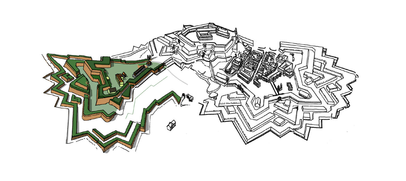
1.) COMMUNICATION AND KAMENICA GATE: They are located in ramparts of the right and left wing of the Hornwerk and connect the two-horned bastion with other fortification structures of the complex on the main access road to the Upper Fortress and further on at Kamenica road. The gates were fortified during the first half of the 18th century and designed using the same pattern as open gates with the facades in the form of decoratively shaped pillars.
2.) MONUMENT TO THE PATRIOTS EXECUTED IN 1914: The Monument to the Serbs from Srem who were executed by the Austrian Army in 1914 as a retribution for the entry of the Serbian Army in Srem is located in the trench of the Hornwerk’s left wing next to the Communication Gate.
3.) ONE-STOREY BARRACKS OR HORNWERK’S BARRACKS: It was built by the middle of the 18th century at the south-eastern part of the Hornwerk. It is a one-storey building with the Latin alphabet letter L shaped foundations, and an elongated tract positioned in parallel with the rampart that connects the St. Charles’s and St. Elizabeth’s Bastion. Since 1970s, the barracks accommodate the Academy of Arts.
4.) ASSAULT GATE OF THE GREAT WATER TRENCH OR HORNWERK GATE: It was constructed during the first decades of the 18th century in a Baroque style. The gate is located at the exit from the tunnel, in the axis of the south-eastern Hornwerk’s bastion front and connects the northern plateau with the great trench between the curtain wall and St. Eugene’s ravelin.
5.) ST. CATHERINE’S RAVELIN: It was constructed in front of the eastern rampart of St. Elizabeth’s bastion. The revetments were used to connect the ravelin with the counterguards-protective fortification structures of the bastion.
6.) ST. ELIZABETH’S BASTION: The south-eastern bastion of the Hornwerk was constructed during the first decades of the 18th century. The bastion is connected with the fortification structures of the Upper Fortress with the left wing ramparts. In addition to the escarp galleries of the countermine system the inner structure of the bastion also hides the casemates with cannon openings facing the trench.
7.) ST. CHARLES’S BASTION: The south-eastern bastion of the Hornwerk was constructed during the first decades of the 18th century. The protruding position of the bastion reinforced with the underground military galleries of the countermine system built in the escarp and casemated so-called German batteries located in front of the western rampart provided a full control over the Danube flow as well as over the southern access points to the Fortress. The interior of the bastion hides the casemates with cannon openings used to defend the main trench and the Assault Gate.
8.) ST. EUGENE’S RAVELIN: The protruding fortification structure of a triangular shape constructed in front of the curtain wall, between St. Charles’s and St. Elizabeth’s bastions for the purpose of preventing the perforation of the cross section profile and defensive installations of the great trench’s Assault Gate.
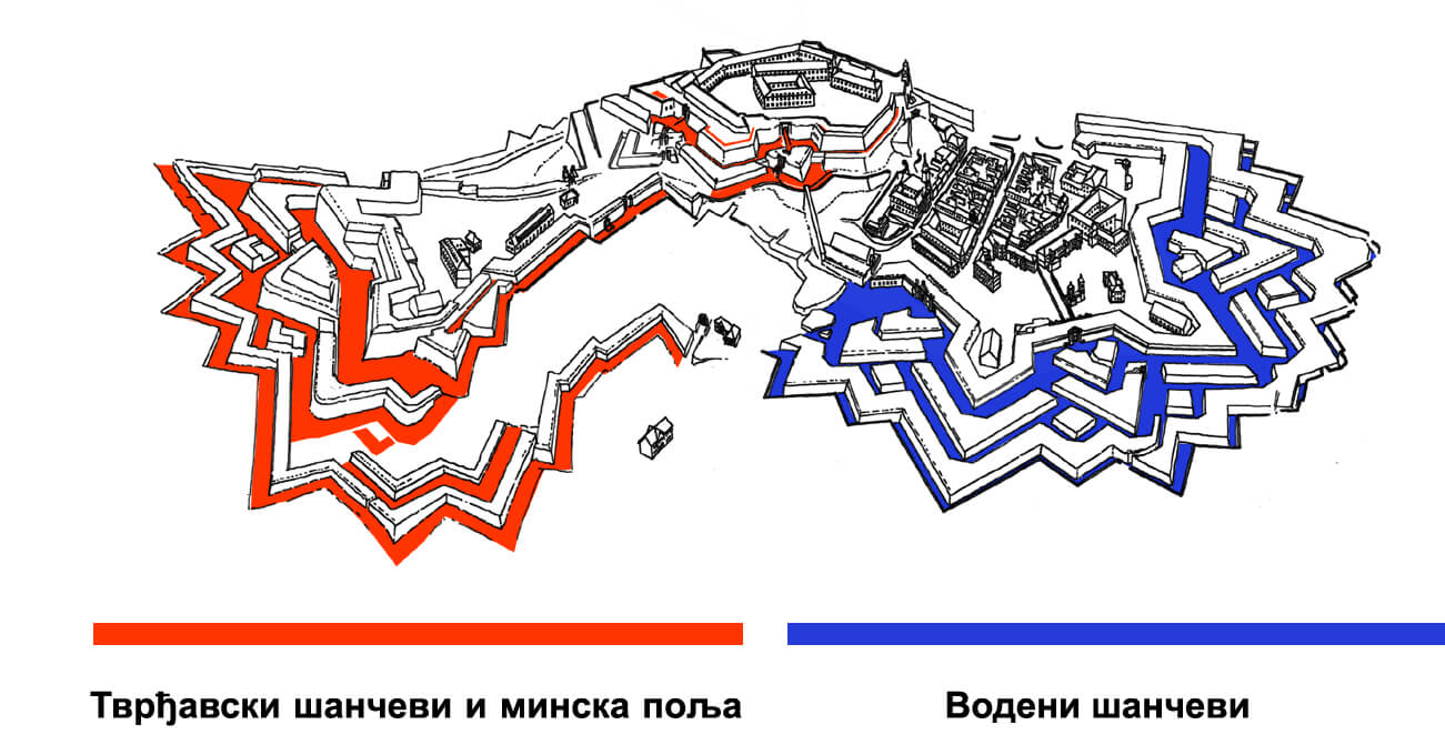
Fortress trenches and mine fields
The Upper Fortress and the Hornwerk are girded by multilayered, dry land, sharp angled and spacious trenches located between the bastions, ravelins and counterguards that descend gradually towards the foothill, spreading up to the outer covered trenches surrounding the entire fortification. The trenches served a dual purpose – during the peace times they were used for manoeuvring purposes, while during the war times they fulfilled a defensive role. Apart from the Antwerp Fortress, the Petrovaradin Fortress had the largest mine system in the world that was buried beneath the trenches and was designed to impose large scale damages to the enemy armies using the regulated explosions.
Water trenches
The trenches were formed during the first half of the 18th century as a protruding defensive installation for protection of the Lower Fortress, namely the Water City. The trenches represented a complex system of sharp angled massive ramparts and canals with numerous fortification structures surrounding the Fortress towards the Danube that as multilayered defence system used the water level as natural obstacle.